---
title: Tropical Depression Nine Forms in Gulf, Hurricane Expected | WeatherBug | WeatherBug
description: Tropical development in the Gulf is now looking increasingly likely, and residents along the northern Gulf Coast should be paying close attention over the next several days.
canonical: https://www.weatherbug.com/news/Tracking%20Tropics%20October%202026%20Gulf%20Storm
og:title: Tropical Depression Nine Forms in Gulf, Hurricane Expected | WeatherBug | WeatherBug
og:description: Tropical development in the Gulf is now looking increasingly likely, and residents along the northern Gulf Coast should be paying close attention over the next several days.
og:url: https://www.weatherbug.com/news/Tracking%20Tropics%20October%202026%20Gulf%20Storm
og:site_name: WeatherBug
og:locale: en_US
og:image: https://cms-assets-con.cdn.weatherbug.net/assets/contentitems/f1/f11fe756-65ba-4dcb-ab6e-cfa34ac73c2f/52e0ce98-d40a-4283-82d1-d0fe816ebf4b/4e145354-a0bb-4087-9c9a-37a7161af044.png
og:image:width: 800
og:image:height: 600
og:image:alt: Probability of development from the National Hurricane Center. Update: Tuesday, October 6, 2026 2pm ET
og:type: article
article:published_time: 2026-10-06T21:12:15Z
article:modified_time: 2026-10-06T21:12:15Z
article:author: By WeatherBug Meteorologist, Brittney Gomez
article:tag: tropics
article:tag: hurricane
article:tag: tropical
article:tag: storm
article:tag: hurricane
article:tag: Gulf
article:tag: Lousiana
article:tag: Florida
article:tag: Alabama
twitter:card: summary_large_image
twitter:title: Tropical Depression Nine Forms in Gulf, Hurricane Expected | WeatherBug
twitter:description: Tropical development in the Gulf is now looking increasingly likely, and residents along the northern Gulf Coast should be paying close attention over the next several days.
twitter:image: https://cms-assets-con.cdn.weatherbug.net/assets/contentitems/f1/f11fe756-65ba-4dcb-ab6e-cfa34ac73c2f/52e0ce98-d40a-4283-82d1-d0fe816ebf4b/4e145354-a0bb-4087-9c9a-37a7161af044.png
---
[](/weather-forecast/now)
[Missing translation for key: backTo forecast](/weather-forecast/now)
# Tropical Depression Nine Forms in Gulf, Hurricane Expected
October 6, 2026 at 05:12 PM EDT
By WeatherBug Meteorologist, Brittney Gomez
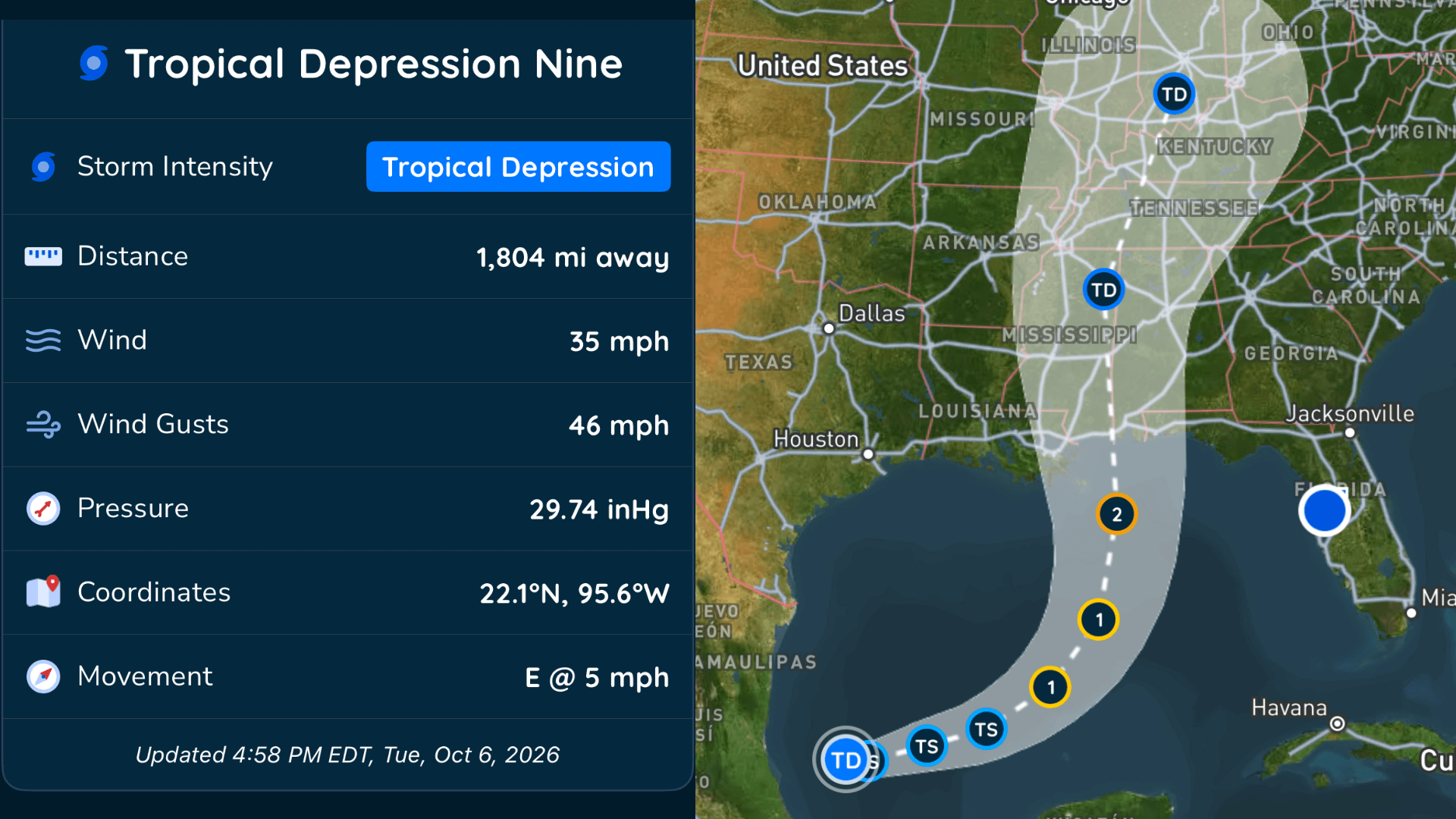
The system we've been watching in the Gulf has officially developed.
**Tropical Depression Nine formed over the southwestern Gulf Tuesday**, and the National Hurricane Center expects it to strengthen as it moves toward the northern Gulf Coast later this week.
The depression has developed a closed circulation with increasingly organized showers and thunderstorms, officially making it the **ninth tropical depression of the Atlantic hurricane season.**
And strengthening is expected soon.
## **Tropical Storm Wednesday, Hurricane Thursday**
Environmental conditions over the Gulf are generally favorable for strengthening over the next few days.
The National Hurricane Center expects Tropical Depression Nine to become a **tropical storm by early Wednesday and a hurricane on Thursday.**
The system is currently compact, which could help it strengthen steadily while conditions remain favorable.
The hurricane is expected to reach its peak intensity before reaching the northern Gulf Coast. Increasing wind shear could cause some weakening as it gets closer to land, but the National Hurricane Center still expects it to be a **dangerous hurricane at landfall.**
There is also some uncertainty surrounding exactly how strong it could become, with some forecast models stronger than the current official forecast.
##
## **Where Is It Headed?**
Tropical Depression Nine is barely moving right now, but that won't last.
The system is expected to slowly move east or east-northeast over the next couple of days. By Friday, a significant change in the weather pattern should cause it to make a **sharp turn toward the northeast and accelerate toward the northern Gulf Coast.**
Landfall is currently expected sometime **Friday into early Saturday.**
However, there is still significant uncertainty surrounding exactly **where the system makes that northeast turn and how quickly it approaches the coast.**
That's important because relatively small changes in when that turn occurs could change which areas ultimately experience the greatest impacts.
##
## **New Data Could Help Improve the Forecast**
Meteorologists are getting additional information that should help refine the forecast.
A **NOAA Gulfstream IV jet is sampling the environment surrounding the storm**, while special weather balloon launches are collecting additional atmospheric data across the south-central U.S.
That information will be fed into forecast models, giving them a more detailed look at the environment steering and influencing the storm.
As those new observations are incorporated, we should get a better idea of the system's eventual track and intensity.
##
## **Don't Focus Only on the Center Line**
The system is expected to remain relatively compact over the next few days, but that could change considerably as it approaches the northern Gulf Coast.
The National Hurricane Center expects the storm to **grow significantly in size, particularly on its eastern side**, as it gets closer to land.
That means impacts won't be limited to wherever the center ultimately crosses the coast.
With uncertainty remaining in both the track and eventual size of the hurricane, residents should avoid focusing on one specific forecast point or line.
##
## **Hurricane Watches Could Be Issued Wednesday**
There is an **increasing risk of dangerous winds and storm surge along portions of the northern Gulf Coast**, and hurricane and storm surge watches could be needed as soon as Wednesday.
Anyone from **Louisiana to the Florida Panhandle** should closely monitor forecast updates and make sure their hurricane plan is ready.
Now is the time to know your evacuation zone, make sure you can receive weather alerts, charge portable batteries, check emergency supplies and secure anything outside that could become dangerous in strong winds.
Don't wait until a warning is issued to start thinking about what you'll need.
##
## **Heavy Rain and Flooding Are Also Concerns**
Wind won't be the only threat.
The system is expected to bring **heavy rainfall to portions of the central U.S. Gulf Coast from Friday into the weekend.**
That could lead to **flash flooding and urban flooding**, along with isolated river flooding.
The western Yucatan Peninsula could see impacts first. As the depression strengthens and moves slowly eastward, **heavy rain and gusty winds are possible there on Thursday.**
****IMPORTANT: This article will not be updated as frequently as new forecasts are issued. The National Hurricane Center issues updates every three hours. For the latest, most up-to-date forecast, visit the WeatherBug Hurricane Center: **
We use technologies, such as cookies, to analyze your use (i.e., pages visited), to customize content, for our internal analytics purposes and for security and other purposes. By continuing to use this website, you agree to this usage. Please review our [privacy policy](/legal/privacy) for more details as well as for information on how to contact us to object to these activities. [Ad Choices](/legal/privacy#digitaladvertisingandyourchoices)
```json
{"@context":"https://schema.org","@type":"NewsArticle","mainEntityOfPage":{"@type":"WebPage","@id":"https://www.weatherbug.com/news/Tracking Tropics October 2026 Gulf Storm"},"headline":"Tropical Depression Nine Forms in Gulf, Hurricane Expected","description":"Tropical development in the Gulf is now looking increasingly likely, and residents along the northern Gulf Coast should be paying close attention over the next several days.","image":["https://cms-assets-con.cdn.weatherbug.net/assets/contentitems/f1/f11fe756-65ba-4dcb-ab6e-cfa34ac73c2f/52e0ce98-d40a-4283-82d1-d0fe816ebf4b/4e145354-a0bb-4087-9c9a-37a7161af044.png"],"datePublished":"2026-10-06T21:12:15Z","dateModified":"2026-10-06T21:12:15Z","dateCreated":"2026-10-06T18:13:19Z","articleSection":"Weather News","keywords":"tropics,hurricane,tropical,storm,hurricane,Gulf,Lousiana,Florida,Alabama","articleBody":"The system we've been watching in the Gulf has officially developed.
Tropical Depression Nine formed over the southwestern Gulf Tuesday, and the National Hurricane Center expects it to strengthen as it moves toward the northern Gulf Coast later this week.
The depression has developed a closed circulation with increasingly organized showers and thunderstorms, officially making it the ninth tropical depression of the Atlantic hurricane season.
And strengthening is expected soon.
Tropical Storm Wednesday, Hurricane Thursday
Environmental conditions over the Gulf are generally favorable for strengthening over the next few days.
The National Hurricane Center expects Tropical Depression Nine to become a tropical storm by early Wednesday and a hurricane on Thursday.
The system is currently compact, which could help it strengthen steadily while conditions remain favorable.
The hurricane is expected to reach its peak intensity before reaching the northern Gulf Coast. Increasing wind shear could cause some weakening as it gets closer to land, but the National Hurricane Center still expects it to be a dangerous hurricane at landfall.
There is also some uncertainty surrounding exactly how strong it could become, with some forecast models stronger than the current official forecast.
Where Is It Headed?
Tropical Depression Nine is barely moving right now, but that won't last.
The system is expected to slowly move east or east-northeast over the next couple of days. By Friday, a significant change in the weather pattern should cause it to make a sharp turn toward the northeast and accelerate toward the northern Gulf Coast.
Landfall is currently expected sometime Friday into early Saturday.
However, there is still significant uncertainty surrounding exactly where the system makes that northeast turn and how quickly it approaches the coast.
That's important because relatively small changes in when that turn occurs could change which areas ultimately experience the greatest impacts.
New Data Could Help Improve the Forecast
Meteorologists are getting additional information that should help refine the forecast.
A NOAA Gulfstream IV jet is sampling the environment surrounding the storm, while special weather balloon launches are collecting additional atmospheric data across the south-central U.S.
That information will be fed into forecast models, giving them a more detailed look at the environment steering and influencing the storm.
As those new observations are incorporated, we should get a better idea of the system's eventual track and intensity.
Don't Focus Only on the Center Line
The system is expected to remain relatively compact over the next few days, but that could change considerably as it approaches the northern Gulf Coast.
The National Hurricane Center expects the storm to grow significantly in size, particularly on its eastern side, as it gets closer to land.
That means impacts won't be limited to wherever the center ultimately crosses the coast.
With uncertainty remaining in both the track and eventual size of the hurricane, residents should avoid focusing on one specific forecast point or line.
Hurricane Watches Could Be Issued Wednesday
There is an increasing risk of dangerous winds and storm surge along portions of the northern Gulf Coast, and hurricane and storm surge watches could be needed as soon as Wednesday.
Anyone from Louisiana to the Florida Panhandle should closely monitor forecast updates and make sure their hurricane plan is ready.
Now is the time to know your evacuation zone, make sure you can receive weather alerts, charge portable batteries, check emergency supplies and secure anything outside that could become dangerous in strong winds.
Don't wait until a warning is issued to start thinking about what you'll need.
Heavy Rain and Flooding Are Also Concerns
Wind won't be the only threat.
The system is expected to bring heavy rainfall to portions of the central U.S. Gulf Coast from Friday into the weekend.
That could lead to flash flooding and urban flooding, along with isolated river flooding.
The western Yucatan Peninsula could see impacts first. As the depression strengthens and moves slowly eastward, heavy rain and gusty winds are possible there on Thursday.
IMPORTANT: This article will not be updated as frequently as new forecasts are issued. The National Hurricane Center issues updates every three hours. For the latest, most up-to-date forecast, visit the WeatherBug Hurricane Center: https://www.weatherbug.com/hurricane/
","author":{"@type":"Person","name":"By WeatherBug Meteorologist, Brittney Gomez","url":"https://www.weatherbug.com"},"publisher":{"@type":"Organization","name":"WeatherBug","logo":{"@type":"ImageObject","url":"https://www.weatherbug.com/images/sharing/f1ff28ba-6f06-4745-a782-011a20397e16.png"}}}
{"@context":"https://schema.org","@type":"WebSite","mainEntityOfPage":{"@type":"WebPage","@id":"https://www.weatherbug.com/news/Tracking%20Tropics%20October%202026%20Gulf%20Storm","relatedLink":"https://www.weatherbug.com/news/Tracking%20Tropics%20October%202026%20Gulf%20Storm"},"name":"WeatherBug","url":"https://www.weatherbug.com/news/Tracking%20Tropics%20October%202026%20Gulf%20Storm","headline":"Tropical Depression Nine Forms in Gulf, Hurricane Expected","description":"Tropical development in the Gulf is now looking increasingly likely, and residents along the northern Gulf Coast should be paying close attention over the next several days.","dateModified":"2026-10-06T21:12:15Z","publisher":{"@type":"Organization","name":"WeatherBug","url":"https://www.weatherbug.com","sameAs":["https://www.facebook.com/WeatherBug","https://instagram.com/WeatherBug","https://www.linkedin.com/company/weatherbug","https://www.pinterest.com/weatherbug","https://twitter.com/WeatherBug","https://www.youtube.com/user/WeatherBugVideo"],"logo":{"@type":"ImageObject","url":"https://www.weatherbug.com/images/logos/weatherbug_logo_620x447.png"}},"author":{"@type":"Organization","name":"WeatherBug","url":"https://www.weatherbug.com","sameAs":["https://www.facebook.com/WeatherBug","https://instagram.com/WeatherBug","https://www.linkedin.com/company/weatherbug","https://www.pinterest.com/weatherbug","https://twitter.com/WeatherBug","https://www.youtube.com/user/WeatherBugVideo"],"logo":{"@type":"ImageObject","url":"https://www.weatherbug.com/images/logos/weatherbug_logo_620x447.png"}}}
{"@context":"https://schema.org","@type":"Organization","name":"WeatherBug","logo":"https://www.weatherbug.com/images/logos/weatherbug_logo_620x447.png","url":"https://www.weatherbug.com","sameAs":["https://www.facebook.com/WeatherBug","https://instagram.com/WeatherBug","https://www.linkedin.com/company/weatherbug","https://www.pinterest.com/weatherbug","https://twitter.com/WeatherBug","https://www.youtube.com/user/WeatherBugVideo"]}
```